GTEC3D-owned Leica Geosystems RTC360 laser scanner on tripod, high-speed 3D scanner accurate to 3 mil.

Our Services

GTEC3D provides advanced reality capture solutions for the architecture, engineering, and construction (AEC) industries, specializing in 3D laser scanning, drone services, BIM integration, and point cloud analysis. Their services aim to create accurate digital twins of existing conditions to minimize project delays and errors. 
Here is an overview of the services
GTEC3D provides:
  • Here is an overview of their services:
    • 3D Laser Scanning: Uses high-precision scanners (e.g., Leica RTC360) to capture millions of data points of existing structures, creating reliable foundations for design and renovation projects. Specialized services include above-ceiling and maritime scanning.
    • Drone Technology: Employs UAVs to capture exterior data, seamlessly merging it with interior scans to create comprehensive indoor/outdoor point clouds.
    • Point Cloud Analysis: Processes raw scan data by cleaning and registering it into structured, downloadable formats (.LGS, Recap, .e57) for integration into client workflows.
    • BIM Work: Transforms point clouds into intelligent BIM models using Autodesk Revit (Scan to BIM), generating parametric digital representations for planning, coordination, and as-built documentation.

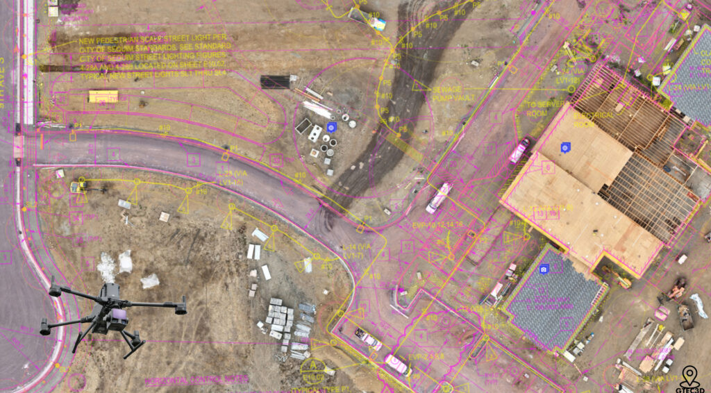
Utilizing advanced LiDAR and photogrammetry to capture existing conditions with millimeter accuracy.

“GTEC3D conducting high-precision 3D laser scanning on a commercial site in Los Angeles, California.”

Aerial Mapping & Inspection

Efficient aerial data collection for large sites, complex infrastructure, and dangerous-to-reach assets.

GTEC3d drone operation using a DJI Mavic 4T to capture aerial imagery for a high-resolution orthomosaic site map overlay for construction drawings.

BIM Services & Digital Twins

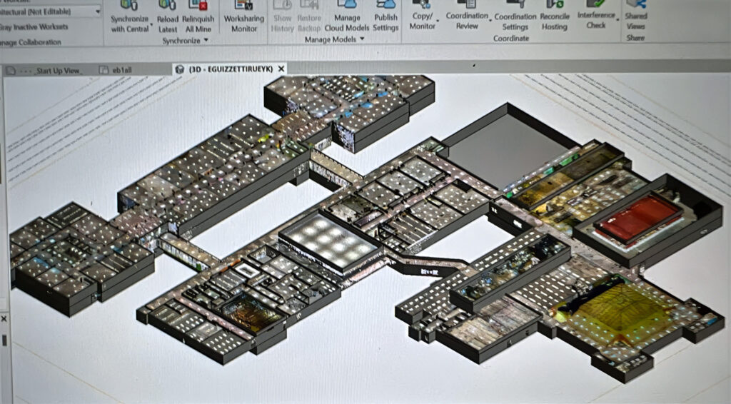
Transforming scan data into intelligent 3D models for design, coordination, and facility management.

GTEC3D laser scanning Ed Landreth Hall at TCU for BIM services

Construction Progress Monitoring

Providing regular, accurate documentation and data visualization throughout the project lifecycle.

GTEC3d team performing laser scanning on a high-rise floor deck in Portland, Oregon, prior to concrete pour to verify as-built conditions.

Dimensional Quality Control (QA/QC)

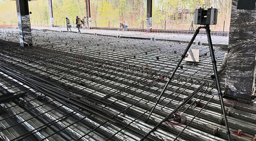
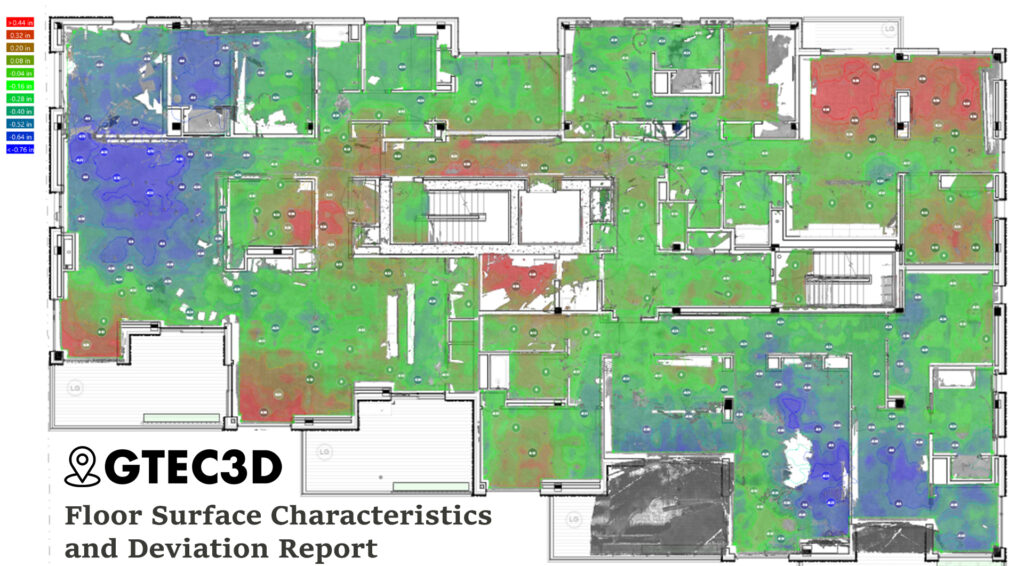
Analyzing captured 3D data to verify construction accuracy against design tolerances and industry standards. Ensure everything is built correctly the first time.

Heatmap showing floor flatness and levelness analysis of a concrete slab for Hacker Architects' Portland project, generated from Leica RTC360 laser scan data.

FAQ

The primary difference is comprehensiveness versus selectivity.


Traditional surveying captures data points one at a time, based on where the surveyor physically sets up their instruments. This method is effective for specific boundary lines or control points but often results in a selective dataset that requires assumptions between measurement points.


3D laser scanning, the core of our reality capture services, captures millions of data points per second (creating a “point cloud“) covering every visible surface of a site or building, all in a fraction of the time.

Safety and regulatory compliance are our top priorities. Operating drones for commercial purposes, like data collection for BIM services or reality capture, is strictly regulated by the Federal Aviation Administration (FAA).

This is an ideal use case for GTEC3D‘s integrated services, combining reality capture with our expert BIM services to bridge the gap between physical reality and digital asset management. 

We solve this challenge by:
  • Capturing Existing Conditions: Our teams deploy 3D laser scanning technology (sometimes supplemented by our drone services for roofs and facades) to capture millions of data points of your entire building, creating a highly accurate “as-built” point cloud.
  • Developing Intelligent BIM Models: We use this precise point cloud data, which is far more accurate than manual measurements, to author a comprehensive Building Information Model (BIM). This isn’t just a 3D model; it’s an intelligent database where every wall, pipe, and piece of equipment is embedded with critical information.
  • Enabling Proactive Facility Management: The resulting BIM deliverable serves as a “single source of truth” for the entire building lifecycle. Your facilities team can use this model for:
    • Space Management & Planning: Accurately track space utilization and plan reconfigurations.
    • Maintenance & Operations: Access data on equipment specifications, maintenance schedules, and locations directly within the model.
    • Future Renovations: Design future projects with confidence, minimizing costly conflicts and change orders by detecting clashes digitally before construction begins. 
By leveraging GTEC3D‘s services, you transform outdated documentation into a dynamic, data-rich asset that provides significant long-term operational efficiency and cost savings.
GTEC3D utilizes a streamlined and transparent process to develop accurate project proposals. Our goal is to ensure the proposed solution perfectly matches your project requirements and expected outcomes.
 
Here is the information we typically need to generate a precise bid for our laser scanning and reality capture services:
 
1. Define the Project Scope:
  • What needs scanning? (e.g., A full university building like Ed Landreth Hall, a specific floor of a plant, an exterior facade, or an entire commercial site?)
  • Total square footage/area: The size and complexity are primary cost drivers.
  • Environment type: Is it an open space, a complex industrial environment with many pipes, or an active construction zone? Complexity affects scanning time and data processing effort.
2. Determine Required Deliverables:
  • What is the end goal? Are you using the data for existing conditions documentation, renovation design, or facility management?
  • Which format do you need? (e.g., Raw point cloud data, 2D CAD drawings, or a fully intelligent BIM deliverable in Revit or AutoCAD formats?) The level of detail required in the final model significantly impacts the bid.
3. Timeline and Logistics:
  • When does the data need to be captured and delivered? Expedited timelines may affect pricing.
  • Site access: Clear access during normal business hours versus night shifts or restricted access impacts operational costs.
 
Our Process:
 
Once we receive this information, a GTEC3D project manager will provide a detailed proposal outlining the project methodology, the specific laser scanning or drone services to be deployed, the timeline for data capture and processing, and the final fixed price for all agreed-upon deliverables.


GTEC3D provides comprehensive laser scanningreality capturedrone services, and BIM services across a broad geographic scope.
 
Our service area is not limited to a single region; GTEC3D actively undertakes projects all over the US and Japan.
 
We mobilize our teams to meet the needs of clients globally, delivering consistent, high-quality data capture and BIM deliverables wherever your project is located.
 

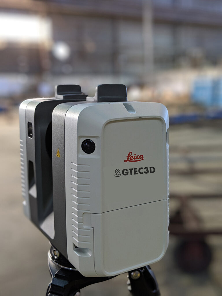
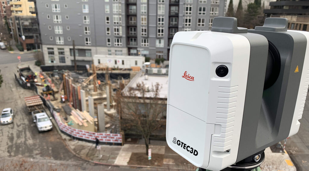
GTEC3D employs a specialized fleet of Leica Geosystems laser scanners, utilizing specific models optimized for different project requirements to ensure maximum efficiency and data quality. Our primary scanners are the 

 for rapid, agile capture and the 

 for long-range precision. 

The RTC360 is GTEC3D’s go-to scanner for projects requiring speed, agility, and portability, such as complex interior building documentation or mid-range external facades.

  • Speed & Efficiency: It captures data at an extremely high rate of up to 2 million points per second, allowing a full-dome scan and HDR image capture in under two minutes.
  • Automated Workflow: The integrated Visual Inertial System (VIS) automatically tracks the scanner’s movement between setups, enabling real-time, targetless field registration and drastically reducing office processing time.
  • Use Cases: Ideal for fast-paced construction sites, BIM applications, and mid-sized architectural projects with a typical range of up to 130 meters.
The  is GTEC3D’s long-range powerhouse, used when projects involve vast distances, large infrastructure, or dangerous, inaccessible areas where safety requires remote scanning.
  • Unsurpassed Range: The defining feature of the 
    P50 is its ability to capture high-quality 3D data at ranges exceeding 1 kilometer.
  • Survey-Grade Accuracy: It delivers the highest quality 3D data and HDR imaging with low range noise and survey-grade dual-axis compensation, forming the foundation for highly detailed point clouds even at great distances.
  • Use Cases: Essential for documenting large civil infrastructure like bridges, dams, expansive industrial complexes, open-pit mines, or the exterior of skyscrapers. 
By leveraging the unique capabilities of both the agile  and the long-range GTEC3D ensures we select the optimal technology for every client’s specific reality capture needs, whether across the US or in Japan. 

Data You Can Build On: GTEC3D Ensures Project Certainty with Scanning, Drones, & BIM

Don’t Risk Costly Rework. Lock In Project Certainty Today.

Get a Free GTEC3D Reality Capture Proposal Now.

© 2020 All Rights Reserved.